

There is a specific criterion that the South African Weather Service applies to each town or city, in order to determine whether heat wave conditions are met or not.
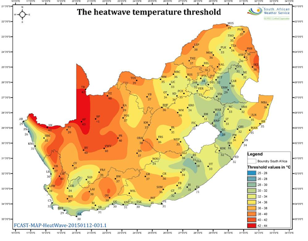
The criterion reads as follows: If the maximum temperature at a particular town is expected to meet or exceed 5 degrees C above the average maximum temperature of “the hottest month” for that particular place, as well as persisting in that mode for 3 days or more, then a heat wave may be declared. For ease of use by SAWS meteorologists, a detailed map of the “heat wave threshold” has been compiled (see figure 1 below), using the latest climatological data to hand. This threshold is thus the maximum temperature which needs to be met or exceeded, for a heat wave to occur.
Heat wave temperature thresholds over South Africa
Heat wave precautions
a. Stay indoors in a well-ventilated or air conditioned room.
b. If working outside, wear protective clothing (head-gear, etc.) and take breaks at regular intervals.
c. Avoid playing strenuous sports or engaging in excessive manual labour, as one runs the risk of heat exhaustion or sunstroke.
d. Dress in cool, lightweight clothes which are not constricting.
e. The wearing of hats (preferably with a wide brim) as well as the generous application of sunblock should be encouraged if one is outdoors for any length of time.
f. Remain adequately hydrated by drinking plenty of liquids (not alcohol).
g. Outside playtime for children should ideally be restricted or prohibited between 10:00 and 16:00.
h. The aged as well as infants are particularly vulnerable to dehydration and/or heatstroke and should be afforded extra care and attention during prolonged spells of hot weather.
The Seasons
One finds disagreement on the starting dates of the seasons at both the scientific and the lay level. There are however three basic ways in which starting dates may be assigned. South Africa does not really experience four distinct seasons. Throughout South Africa the transitional seasons of Autumn and Spring tend to be very short. Most analysis of climate is done using the assumption that January is mid-summer and July min-winter.
Astronomical basis
The instances at which the solstices and equinoxes occur can be accurately calculated. Earlier astronomical textbooks often defined the four seasons as starting on the dates of the corresponding equinoxes and solstices. But more recent books avoid defining the seasons in any way: two new editions of earlier books have in fact deleted their previous definitions. Moreover, expressions such as spring equinox and summer solstice are no longer used in astronomy. Instead, the four astronomical instances are identified as the ascending and descending equinoxes in March and September respectively, and the northern and southern solstices in June and December. One reason for these changes is to avoid the inevitable confusion of northern and southern hemisphere seasons: the ascending equinox in March is the spring equinox in the northern hemisphere, but the autumnal equinox in the southern hemisphere.
Thus the earlier astronomical definitions of the starting dates of the seasons are no longer relevant, and their use should be discouraged.
Climatological basis
A further failing of the earlier astronomically defined seasons is that they simply did not describe the real seasons as actually experienced. As one of the contributors to this article expressed it, summer does not start four days before Christmas. A climatologically definition of the seasons would obviously be more realistic. In the temperate latitudes of Europe and North America the climatological seasons are conventionally defined as shown in Table I. The equivalent seasons in the southern hemisphere are of course six months out of phase with those in the northern hemisphere, and are also given in Table I.
The use of intervals of exactly three calendar months for the conventional temperate latitude seasons is a matter of convenience rather than climatological reality. For example, in England the latter part of November is wintry rather than autumnal, with cold, foggy days occurring fairly frequently. Elsewhere in the world the disparity becomes even worse. Climatologists therefore ignore the conventional seasonal nomenclature and use labels which are more appropriate to the climate of a particular region: for example hot season, cold season, post-rainy season, etc. The durations of these seasons depend on the climate of the region, and have no direct relationship to either the astronomical seasons or the calendar months. Thus September is spring-like in Gauteng, with cool mornings and warm afternoons, whereas it is still winter-like in the Western Cape, with the possibility of snow on the Eastern Cape mountains. Unfortunately the lay public would find it too confusing if a different set of seasonal dates was adopted for different parts of the country in order to encompass this variability.
Phenological basis
Phenological phenomena (this is, those relating to the natural seasonal behaviour of plants and animals) are the most fundamental markers of the changing seasons. This can be seen from the etymology of the names of the seasons in various languages. Thus in English, spring, from Anglo-Saxon for rise or burst forth, is the season when sap rises and plants put out buds. Autumn, from early Latin for ripen, is the season when crops reach maturity and can be harvested.
Unfortunately, an appeal to the phonological seasons merely confounds the confusion. In parts of Europe the phonological seasons are taken to occur one month earlier than the conventional climatic season, where in other parts and in the USA the two systems coincide. In any case, May Day (1st May) rather than the first day of spring however that may be chosen seems to be the preferred date for celebrating this season in Europe.
In South Africa, the wide range of climatic regions and phenotypes (compare coastal KwaZulu-Natal with the south-western Cape) also adds to the difficulty of defining a clear-cut seasonal calendar based on phenology.
Conclusion
Apart from rejecting the astronomically-based seasons in compliance with modern astronomical usage, there are no firm grounds for choosing one set of dates rather than another for the starting dates of the seasons. There is certainly no official designation of the starting dates. On broad climatological and sociological grounds, however, choosing the dates in Table I would have the advantage of conformity established conventions.
On the basis of these conclusions, the following recommendations are suggested:
Adopt the seasonal calendar given in Table I for the southern hemisphere.
Emphasize strongly that these are conventional or traditional dates, and that an official calendar does not exist.

Table I
Rainfall is measured at 08:00 SAST. The rain accumulated in the bucket of the rain gauge is poured into a specially calibrated measuring glass and the millimetre reading is recorded, whereafter the water is discarded. The rainfall measured between 08:00 SAST yesterday and 08:00 SAST today is recorded against yesterdays date on the database. What is meant by 1 mm of rainfall is rainfall equivalent to 1 litre of water in a 1 square meter box with no runoff, infiltration or evaporation.
The South African Weather Service also has a number of electronic rain gauges called Tipping Bucket rain gauges. These gauges consist of a large cylinder set into the ground. At the top of the cylinder is a funnel that collects and channels the precipitation. The precipitation falls into one of the two small buckets which are balanced side by side. As soon as it starts raining one of the buckets fills with water. After an amount equal to 0.2 mm falls into the bucket the bucket tips and an electrical signal is sent to a recorder. The next bucket is then in place to collect precipitation. The two buckets seesaw up and down collecting and recording the rainfall. The instrument is thus able to record not only the amount of rain that falls but when it started and stopped raining.
Different rainfall intensities are described in the image below.
No these phenomena are not the same thing. A tropical cyclone is an intensely developed low-pressure cell that usually occurs over warm oceans. Its diameter can range between 200 and 2 000 km. Tropical cyclones can last for a few days.
A tornado is a violent rotating column of air that extends from a thunderstorm and is much smaller in diameter, typically less than a few hundred meters, but some are larger than 1 km. They usually occur over land. Tornados are generally short lived and can be on the ground for a few seconds to minutes. Some have been know to be on the ground for over an hour but these are rare. If a tornado occurs over water is called a water spout.
What are my chances of being struck by lightning?
Lightning occurs with every thunderstorm and must be expected as soon as thunderstorms form. Lightning results from the build-up and discharge of electrical energy between positively and negatively charged areas in the atmosphere and clouds. The most lightning occurs between clouds but it is the ground strikes that are dangerous. Your chances of being struck by lightning are estimated to be 1 in 350,000 but could be reduced by following lightning safety rules.
Precautions: Stay indoors during a lightning storm and if you are travelling, stay in the vehicle. When indoors stay away from windows, do not hold any metal object nor use any electrical appliance. Do not use the telephone. Do not take a bath or shower during the lightning storm. If you are caught in the open, seek shelter in a building. Avoid hilltops and do not shelter under lone trees nor in isolated sheds. Keep distance from fences, telephone or power lines and steel structures such as pylons and windmills. Do not swim during a lightning storm and seek shelter if you are in a boat. If you are in the open playing sport, seek shelter especially if you are fishing, or playing golf, soccer or rugby.
Note that lightning can occur when it is not raining. Lightning often strikes outside of heavy rain and may occur as far as 16 km away from any rainfall. Rubber-soled shoes and rubber tires provide NO protection from lightning. However, the steel frame of a hard-topped vehicle provides increased protection if you are not touching metal. Although you may be injured if lightning strikes your car, you are much safer inside a vehicle than outside.
Do people who have been struck by lightning carry an electrical charge?
Lightning-struck victims carry no electric charge and should be attended to immediately.
What is heat lightning?
Heat lightning is actually lightning from a thunderstorm too far away for thunder to be heard. However, the storm may be moving in your direction so beware.
How often does lightning occur over the earths surface at any one time?
Over the entire earth, estimates are that 100 lightning flashes occur each second.
How much electricity can one lightning bolt provide?
The resultant electric current from a single lightning bolt can provide enough energy to light a city of 200 000 people for one minute.
Can lightning strike the same place twice?
Yes, lightning can strike the same place twice. The Empire State Building in the USA gets hit about two dozen times per year! One bad storm saw lightning strike the building fifteen times in twenty minutes.
What is a jet stream?
It is a narrow band of strong winds in the atmosphere that controls the movement of high- and low-pressure systems and associated fronts. Wind speeds can reach 380 km/h or higher in certain cases. Jet streams are usually found at 9 - 12 km (30 000 - 40 000 ft) above the surface. It owes it existence to the large temperature contrast between the polar and equatorial regions.
What is an urban heat island?
An urban heat island is an urban area which is significantly warmer than its surroundings. This occurs because roof and paving materials have a low reflectivity and absorb more of the sun's rays than natural surfaces, causing both surface temperature and overall ambient air temperature in an urban area to rise. In addition, there are fewer trees and other natural vegetation to shade buildings, block solar radiation and cool the air by evapotranspiration in urban areas. The urban heat island effect is characterized by city centres commonly having temperatures six degrees higher than that of the surrounding environment.
What is a berg wind?
A berg wind is a hot, dry wind blowing off the interior plateau of South Africa, roughly at right angles to the coast. Berg winds usually occur in winter when there is a low-pressure system along the coastal areas with a high-pressure system over the continent.
What is frost?
Frost is formed in the same way as dew, but occurs when the temperature of the air in contact with the ground is below the freezing point of water (0 ºC). The water vapour changes directly from a gas to a solid state to form tiny ice crystals. Like dew, frost forms during calm, clear nights when the ground and objects near it cool rapidly because the earth’s heat is lost to space.
In South Africa light frost can be expected when the minimum temperatures reach 3 ºC. This is because on a calm night, the ground, where the frost forms, is usually several degrees cooler than the level at which temperature is measured (about 1,2 m above the ground) and thus the ground will probably be at, or below, freezing.
What is black frost?
Black frost occurs when the temperature is below zero but there is not enough moisture in the air to produce visible frost. Its name is derived from the resulting blackened appearance of affected vegetation.
What is dew?
Dew forms when water vapour condenses on objects and solid surfaces on or near the ground because these have cooled during the night time below the dew-point temperature of the air around them. For dew to form, however, there must be moisture in the air and the night must be clear (cloudless) and fairly windless so that the earth can radiate its heat energy out into space.
What is fog?
Fog is a suspension of usually very small water particles, but also sometimes ice particles, that reduces visibility at the surface to distances less than 1 km. Although fog is not usually considered to be a cloud, it has essentially the same properties. The two phenomena differ only in extend that the base of fog is at the ground, whereas clouds are above the ground.
What is smog?
Smog is a mixture of smoke and fog which contains large amounts of soot, sulphur dioxide and other pollutants which act as nuclei around which water condenses.
The recognition of a cloud by having a name and being in a certain class is a useful indication of the nature of a cloud and the atmospheric movements and processes which are present. Classification is based on heights, appearance, whether the cloud consists of liquid water or ice, on the processes which lead to the formation of the clouds. Clouds are classified as low, middle or high level according to their base heights. There are three cloud forms, namely stratiform, cumuliform and cirriform cloud. Stratiform cloud are layers of cloud formed by widespread ascent and cumuliform cloud form as air rises by convection, while fibrous cloud composed of ice crystals are called cirriform cloud. There are then basic cloud types:
Cirrus (Ci)

Formation
High-level ascent
Shape due to wind shear
Characteristics
White, without shading
Delicate filaments
Patches of narrow bands
Fibrous or silky appearance
Hook-shaped feathery filaments
Composed of ice crystals
Precipitation
None
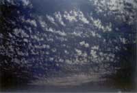
Cirrocumulus (Cc)
Formation
Convection
Develops from cirrus of cirrostratus
Characteristics
Thin white patch, sheet or layer
Very small elements - grains, ripples
Width of less than one finger held at arm's length
Merged or separate
More or less regularly arranged
Precipitation
None
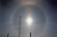
Cirrostratus (Cs)
Formation
Widespread upper-level ascent
Characteristics
Transparent whitish veil
Fibrous or smooth
May cover whole sky
Commonly produces halo
Precipitation
None
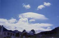
Altocumulus (Ac)
Formation
Convection
Wave flow near mountains
Characteristics
Grey, featureless sheet or layer cloud
Usually waved or in lumps or layers
May be lens-shaped near mountains or islands
White or grey or both white and grey
Smallest elements have apparent width of two fingers when held at arm's length
Precipitation
Virga
Light showers occasionally
Altostratus (As)
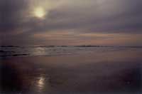
Formation
Widespread ascent
Characteristics
Grey, featureless sheet or layer cloud
Can be fibrous or uniform
Covers whole or part of sky
Sun shines weakly (as if through ground glass)
Great horizontal extent
Precipitation
Rain
Nimbostratus (Ns)

Formation
Widespread ascent
Characteristics
Dark grey cloud layer
Generally covering the sky
Dense and thick enough to hide sun or moon
Base indistinct as a result of continuous rain or snow
Base often lower than 2 500 meters
Precipitation
Rain or snow - almost continuous
Cumulus (Cu)
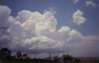
Formation
Convection
Surface heating
Instability
Characteristics
Detached cloud
Develops vertically upwards
In the form of turrets, towers
Tops domed or cauliflower-shaped
Shaped outlines
Sunlit parts are bright white
Base nearly horizontal, relatively dark
Size depends on stage of development
Precipitation
Showers of rain
Snow from large cumulus
Cumulonimbus (Cb)
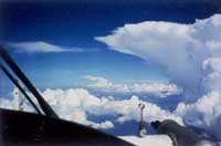
Formation
Convection
Surface heating
Instability
Characteristics
Bulging, dense cloud masses
Huge cumulus cloud
Fibrous top, often anvil-shaped or plume shaped
Base dark and stormy looking
Thunder and lightning common
Low tattered clouds below base
Associated with gusts and squalls
Precipitation
Showers of rain, snow - may be heavy
Hail
Stratocumulus (Sc)
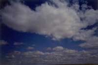
Formation
Spreading out of cumulus (usually evenings)
Turbulent mixing under stable layer
Characteristics
Grey or white layer with darker areas
Often regular undulations
Elements have apparent width of three or more fingers when extended at arms length
Precipitation
Occasional light rain
Drizzle
Stratus (St)
Formation
Low-level ascent or cooling
Due to
Precipitation that has saturated the air
Lifting fog or mist
Characteristics
Grey uniform layer
May be continuous or patchy
Resembling fog, but not on the ground
May appear as shreds of fragments below nimbostratus
May cover tops of mountains or hills
Precipitation
Drizzle
A cold front occurs where a large mass of cold air meets a mass of warmer air, and the cold air advances on the warmer air. The cold air undercuts the warm air pushing it upwards. Cumulonimbus clouds form a well-defined line along the boundary between the air masses. As the cold front passes, the clouds roll by and the air temperature may become noticeably cooler, with temperatures dropping by 5 °C or more within the first hour. Rain, gusty winds, and, sometimes, thunderstorms occur with the passage of the cold front.
On synoptic (weather) charts a cold front is represented by a solid line with triangles along the front pointing towards the warmer air and in the direction of movement. On coloured weather maps, a cold front is drawn in blue.
Occurrence in South Africa
Tornadoes can occur basically anywhere where a thunderstorm is possible. From an analysis of the occurrence of South African tornadoes it became clear that most of them have been observed in Gauteng, the Free State, KwaZulu-Natal (along a line from Pietermaritzburg to Ladysmith) and the northern region of the former Transkei. In figure 1 the eastern part of the country is depicted, showing the more significant events (F2 and F3) from 1905 to 1997.
Some 65% of the South African tornadoes are classified as F0 or F1 (light damage), while more than 90% are classified as F0, F1 or F2 (considerable damage) or less. The tornado which occurred at Harrismith on 15 November 1998 was classified as F2 and the Mount Ayliff tornado which occurred in the Eastern Cape on 18 January 1999 was classified as F4.
Tornadoes can occur basically anywhere where a thunderstorm is possible. From an analysis of the occurrence of South African tornadoes it became clear that most of them have been observed in Gauteng, the Free State, KwaZulu-Natal (along a line from Pietermaritzburg to Ladysmith) and the northern region of the former Transkei. There seems to be a preference to mountainous areas.
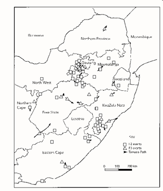
Figure 1
Seasonal Distribution
The seasonal distribution of South African tornadoes is given in figure 2. Most of the events occur in mid-summer from November to January, although a large number of tornadoes have occurred in spring and early summer (September and October) and in the late summer and autumn (February to May). It is also worth mentioning that most tornado events (for which the time of the day were available) occurred in the late afternoon or early evening, typically between 16:00 and 19:00.
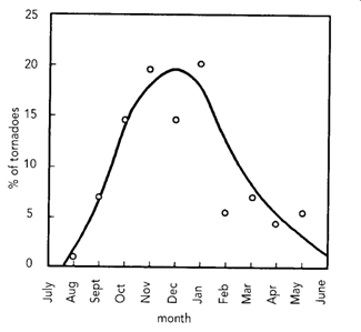
Figure 2
Forecasting Tornadoes
Meteorologists rely on weather radar to provide information on developing storms. Currently in the USA, only a 20-minutes before touchdown prediction is possible by identifying the so-called vortex signature of the tornado on radar.
Storm structure can provide clues about the existence of a tornado, clearly shown in the radar images for the Harrismith tornado. The Bow echo shape in the Harrismith area is typical of severe storms.
Forecasting Tornadoes
A tornado, from the Latin tornare (to turn), is a violent rotating column of air extending from a thunderstorm. Tornadoes are amongst the most violent and destructive of all weather phenomena, but despite the significant amount of research into the origin and prediction thereof, the phenomenon is still not fully understood or predictable. Field research on tornadoes is particularly difficult due to their short lifetime, the small area affected by them and the low probability of occurrence at a particular point.
Where do they come from?
Tornadoes in South Africa are typically associated with very hot air masses and severe thunderstorms. To date scientists do not know exactly how tornadoes are formed, but all the evidence suggests that they develop as a combination of (1) strong spinning effects inside a thunderstorm or in the air surrounding the storm and (2) accelerated strong updrafts (wind moving vertically in an upward direction).
One of the more recent theories explains it as follows: Before thunderstorms develop, a change in wind direction takes place. The wind speed also increases with height. These two factors combined give rise to an invisible, horizontal spinning effect in the lower atmosphere. The rising air within the thunderstorm updraft tilts the rotating air from horizontal to vertical (figure 1). An area of rotation now extends through much of the storm. Most strong and violent tornadoes form within this area of strong rotation.
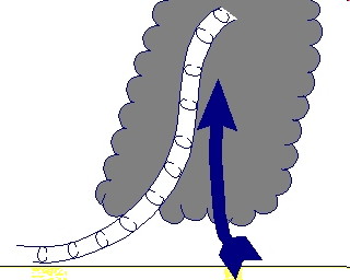
Figure 1
There are a few meteorological conditions necessary for tornado formation. Because of the scientific nature of this, the conditions are only listed and not further discussed here.
A deep layer of mid-atmospheric dry air above a moist surface layer
Steep moisture and temperature gradients
High surface temperatures
Low level convergence and upper level divergence
Vertical wind shear (change in wind direction and speed with height)
Atmospheric instability (air continues to rise once it starts rising)
Characteristics and Classification
Damage Path: Not all tornadoes are strong enough to extend down to the surface of the earth. If a tornado touches the ground the damage path depends on the position within the thunderstorm where the tornado was generated and the topography. The length and width of the path also depends on the speed of the thunderstorm - when the thunderstorm slows down, the path of the tornado widens.
Wind Speed: It is very difficult, if not impossible, to obtain a direct and reliable wind speed record from a tornado. Even in those cases in which standard wind-measuring devices have happened to be present in the tornadic path, the actual wind speeds have been well above the limits of these devices and, besides this, the wind-speed anemometers have been damaged and/or displaced. The only actual measurements currently available are for USA tornadoes. Indirect methods of estimating the wind speeds have generally been used. One such estimate made for a South African event suggested a wind speed in the order of 350 km/h.
Classification: There are several different methods of classifying tornadoes. The most commonly used is the Fujita-Pearson scale classification. This system classifies tornadoes in six intensities, ranging from F0 (no damage) to F5 (incredible damage). The intensity is based on the apparent damage to structures, the extent of the path and other descriptors from which wind speeds are then inferred. 65% of the South African tornadoes are classified as F0 or F1 (light damage), while more than 90% are classified as F0, F1 or F2 (considerable damage) or less. The tornado which occurred at Harrismith on 15 November 1998 was classified as F2 due to the severity of the damage.
For several hundred years many hurricanes in the West Indies were named after the particular saint's day on which the hurricane occurred. The USA meteorologists gave tropical storms women’s names. The origin of using women names is linked to the fact that satellite technology was and is still used to track tropical cyclones. Satellites were first used by the military and it is said that Air Force and Navy meteorologists, who plotted the movements of storms, named these storms after their wives and girlfriends. The official method to name a tropical cyclone however was to refer to its latitude-longitude position but this became confusing when the storms moved. It was found that by using a short, distinctive name enabled meteorologists to exchange detailed information about various storms which may be occurring at the same time in the same ocean basin.
The practice of naming tropical cyclones solely after women came to an end in 1978 when men's and women's names were included in the Eastern North Pacific storm lists. In 1979, male and female names were included in lists for the Atlantic and Gulf of Mexico.
Lists of names are compiled and maintained by various meteorological committees. Each list has a name for each letter of the alphabet starting with A and ending with Z. A name on the list will be replaced if a storm given this name causes extensive damage and loss of life.
Description
A tropical cyclone is a relatively small, intensely developed low pressure cell that usually occur over warm oceans. Its diameter can range between 200 and 2 000 km. It is characterized by a warm centre, very steep pressure gradients and strong cyclonic (clockwise in the southern hemisphere) winds near the Earth's surface. Tropical cyclones with a maximum wind speed of less than 60 km/h are called tropical depressions; when the maximum wind speed ranges between 60 and 110 km/h, they are tropical storms, and when the maximum wind speed exceeds 110 km/h, they are called tropical cyclones. (In the North Atlantic and eastern North Pacific regions it is called hurricanes, in the western North Pacific typhoons.)
Formation
The process by which a disturbance in the pressure pattern forms and subsequently strengthens into a tropical cyclone depends on at least three conditions:
(1) Developing tropical cyclones gather heat and energy through contact with warm ocean waters. This usually happens between 5 and 20 North and South.
(2) The addition of moisture by evaporation of sea water from the sea surface powers them like giant heat engines, i.e. it draws its energy from the evaporation of sea water under the storm.
(3) A wind pattern near the ocean surface that spirals air inward, is also necessary.
The net result of these processes is a towering column of spiralling air with an intense low pressure in its centre. Bands of thunderstorms form, allowing the air to warm further and rise higher into the atmosphere.
Structure
The centre, or eye, of a tropical cyclone is relatively calm and warm. The eye itself is clear, mainly because of gently subsiding air within it. The eye is extremely warm near the top of the storm circulation, reaching temperatures as much as 10°C greater than that of the undisturbed environment at the same altitude. Near the sea surface the air has virtually the same temperature through the storm.
A spectacular wall of cloud (mainly cumulonimbus) rings the edge of the eye from sea level to heights of over 15 km. This ring of cloud, called the eyewall, maybe tens of kilometres thick, while a dense cirrus and altostratus overcast may extend outward several hundred kilometres from the eyewall. The most violent activity takes place in the eyewall. At the top of the eyewall, most of the air is propelled outward, increasing the air's upward motion.
Lifetime
Once a mature tropical cyclone forms, it can last while the atmospheric and oceanic conditions remain favourable - a duration of 1 week is typical. Tropical cyclones decay when they move over land (called landfall) or cold ocean water - more rapidly over land, particularly if the terrain is rough.
TracksTropical cyclones move forward at different speeds. On average a cyclone may travel 200 km in a day. Although tropical cyclones occur in definite regions of the world and generally moves in a westerly direction, their precise tracks are erratic and very difficult to predict.
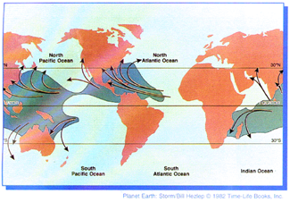
The weather associated with tropical cyclones
Tropical cyclones are always accompanied by torrential rain. A single storm may yield up to 3 000 mm of rain. Heavy rains sometimes occur many days after landfall and are also very destructive. It may give rise to floods.
Because of the steep pressure gradient, strong winds occur. The wind speed rises rapidly from nearly zero in the eye to its maximum value at a radius between 10 and 100 km from the centre. The strongest winds occur near the leading edge (in front) of the storm.
The destruction associated with tropical cyclones results not only from the force of the wind, but also from the storm surge and the waves it generates. The storm surge is experienced as a rapid rise of sea level near that portion of the eyewall associated with onshore winds, sometimes reaching a height of more than 6 metres and accompanied by very large wind-driven waves. Much of the death toll in tropical cyclones is due to the storm surge. The net result of the raised sea level, strong winds and torrential rains is to inflict severe damage on coastlines affected by the storm, especially those which are low-lying.
The standard atmosphere is a conventional vertical structure of the atmosphere characterized by a standard sea-level pressure of 1013,25 hPa (29,92 inches of mercury) and a sea-level air temperature of 15 °C (59 °F).
Ozone is a nearly colourless (but faintly blue) gaseous form of oxygen, with a characteristic odour like that of weak chlorine. It is usually found in trace amounts in the atmosphere, but is primarily found at 30 000 to 150 000 feet. Its production results from photochemical process involving ultraviolet radiation. Because it absorbs harmful ultraviolet radiation at those heights, it is a beneficial gas. What is the difference between stratospheric and tropospheric Ozone? The stratosphere is the region of the Earth's atmosphere from 10 to 50 kilometres above the surface. Approximately 90 per cent of all ozone is produced naturally in this layer. This band of ozone-rich air found in the stratosphere is known as the ozone layer and shields the earth from damaging ultraviolet radiation.
This layer of ozone is thus essential to life on earth. The troposphere extends to between 10 and 18 kilometres above the surface of the Earth and tropospheric ozone often called ground level ozone occurs at the bottom of this layer. The abnormally high concentrations in this layer are caused by human activities in which large amounts of fossil fuels are burnt. Ozone at this level is a major component of smog and thus a form of pollution. Thus Ozone has different effects depending on where it is located in the atmosphere. How is stratospheric Ozone formed? Ozone is created in the stratosphere when highly energetic solar rays strike molecules of oxygen (O2) and cause the two oxygen atoms to split apart. If a freed atom bumps into another O2, it joins up, forming ozone (O3). Ozone is also naturally broken down in the stratosphere by sunlight and by a chemical reaction with various compounds containing nitrogen, hydrogen and chlorine. These chemicals all occur naturally in the atmosphere in very small amounts. In an unpolluted atmosphere there is a dynamic balance between the amount of ozone being produced and the amount of ozone being destroyed. As a result, the total concentration of ozone in the stratosphere remains relatively constant. However, because of release of a number of atmospheric pollutants this delicate balance is being disrupted. This destruction of the ozone has lead to the international effort to limit ozone destructive pollutants and a worldwide effort to preserving the ozone layer.
A weather forecast is given before the date in question and gives an indication of what weather conditions could be expected. Weather forecasts can be made one to two weeks in advance. The forecast skill however drops rapidly during the first week of a forecast, such that daily conditions generally become unpredictable after about a week to ten days. A weather report can only be given for a past period and gives the actual weather conditions that hale already occurred. It can be produced for any time period for any place where the South African Weather Service has a first order station or an automatic weather station (AWS) in operation.
If a rising parcel of air is cooler than the surrounding atmosphere it will tend to sink back to its original position. This is because cool air is more dense or heavier than warmer air. This is referred to as stable air. If a rising parcel of air is warmer than the surrounding atmosphere it will continue to rise. This is because warm air is less dense or lighter than cool air. This is referred to as unstable air.
Maximum temperature The maximum thermometer indicates the highest temperature reached since the thermometer was last reset. Owing to the constriction in the mercury capillary tube, the maximum thermometer is not affected when the temperature drops as this constriction prevents the mercury from returning to the bulb when it is getting colder. The maximum thermometer is only read at the time of the 08:00 SAST observation, and two readings are taken, namely the maximum temperature and the maximum reset value (which should be within 1,5 ºC of the 08:00 observed dry-bulb temperature). The maximum temperature as read between 08:00 SAST yesterday and 08:00 SAST today is recorded against yesterday’s date on the climate database. Minimum temperature The minimum thermometer indicates the lowest temperature reached since the thermometer was last reset. Factors influencing horizontal variations in temperature include distance from the sea, ocean currents and aspect. The difference between wet-bulb temperature and dew-point temperature and relative humidity.
The wet-bulb temperature, dew-point temperature and relative humidity all relate to the amount of moisture in the atmosphere. The wet-bulb temperature of air is measured by a thermometer whose bulb is wrapped in muslin and which is kept moist with distilled water. The evaporation of water from the muslin around the thermometer bulb has a cooling effect and thus the temperature indicated by the wet-bulb thermometer is less than the temperature indicated by a dry-bulb thermometer. The rate of evaporation from the wet-bulb thermometer depends on the humidity of the air. Evaporation is slower when the air is already full of water vapour. The difference in the temperatures indicated by the wet-bulb and dry-bulb thermometers gives a measure of atmospheric humidity. The dew point is the temperature to which the air must be cooled to reach saturation. The difference between the air temperature and the dew-point temperature is proportional to the relative humidity. The closer the two temperatures are, the higher the relative humidity. When the air temperature is the same as the dew-point temperature, the relative humidity is 100%. Condensation will then take place resulting in visible water in the form of either clouds or fog or dew.
The World Meteorological Organization is an intergovernmental organization with a membership of 182 Member States and 6 Territories (on 5 April 2007). It originated from the International Meteorological Organization (IMO), which was founded in 1873. The WMO was established in 1950 and became the specialized agency of the United Nations for meteorology (weather and climate), operational hydrology and related geophysical sciences.Click here to access the WMO Website.
The effect of tropical cyclones on South Africa The tropical cyclone season in our part of the world is from November to April, with the peak frequency in January and February. Only tropical cyclones moving into the Mozambique channel influence South Africa's weather. When this happens, we usually experience dry weather over the interior because of the subsiding air surrounding a tropical cyclone. Only a few move in over or close enough to the land to cause destruction, and then usually north of the 25°S latitude. In such cases, the Northern Province, Mpumalanga and KwaZulu-Natal may experience destructive winds and the risk of flooding. Significant tropical cyclones that had such an effect on South Africa was Domoina which occurred in January 1984, Imboa in February 1984 and more recently Eline in February 2000.
Although the track of a tropical cyclone is very erratic, the Weather Service can still issue timely warnings to the public if a tropical cyclone is approaching densely populated. Tropical cyclones seldom reach South Africa. However a number of tropical cyclones do move into the Mozambique Channel and have an effect on areas surrounding the channel. Which cyclones have affected South Africa The following are a few of the tropical cyclone that have had some effect on southern Africa: Astrid (January 1958) Claude (January 1966) Caroline (14 February 1972) Eugenie (21-22 February 1972) Danae (27-31 January 1976) Emilie (6-8 February 1977) Kolia (March 1980) Justine (March 1982) Domoina (29-31 January 1984) Imboa (10 â 20 February 1984) Eline (8-22 February 2000)
.