
Weather and climate conditions play a dominant role in agricultural production. Extreme weather and climate events such as flash floods, untimely rains, hailstorms, frost, extreme heat, and drought have resulted in losses in farm production such as:
 Weather forecast and seasonal prediction
A weather forecast can be used in planning many field operations such as: spraying, fertiliser applications, irrigation, and preventing damage from frost. Seasonal prediction can assist in selecting crop variety, adjust timing of land preparation, and increase or decrease planted area.
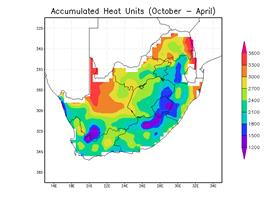
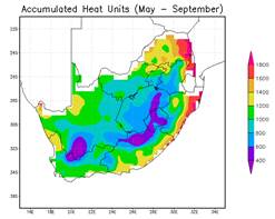
 Heat and chill units
Heat units - quantify the thermal environment of organisms; Chill units - sum of cold weather required to break dormancy. Heat and chill units are used to identify potential growing locations, select suitable hybrids, predict best timing of fertiliser or pesticide application.
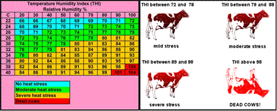
 Animal heat stress indices
The Heat Stress Indices product provides 72-hours forecast maps that show the potential stress livestock experience due to the combination of temperature and humidity conditions. Temperature Humidity Index (THI) - assess the risk of heat stress on dairy cattle, beef cattle and poultry. The product provide guide for the appropriate response activities (e.g., use of cooling technologies) to reduce the impact of heat stress on livestock. Temperature Humidity Index (THI) - assess the risk of heat stress on dairy cattle, beef cattle and poultry. Quantitatively inform cooling needs to minimize the impacts of heat stress on milk and beef production and broilers.
 Frost probability index
The frost probability index calculates the onset and cessation of frost at a specific site. This assists farmers decide the physical risk of early planting or late harvest of field crops.
 Evapotranspiration & soil moisture
Reference evapotranspiration and soil saturation index (SSI) products can assist in water management, irrigation, and flood monitoring.
|
Districts Rainfall Stats (DRS) |
|
|
Additional Information |
|
|
Data Type |
Text |
|
File Format |
Microsoft Excel |
|
File Size |
Small |
|
Frequency |
Monthly |
|
Thematic Application Area/ Target Market |
· Government · Farmers · Researchers · Universities · Financial sectors etc |
|
Coverage |
South Africa
|
|
Dissemination Channels |
|
|
Product Benefits/Impact to end – user |
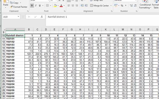
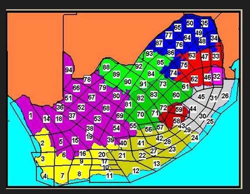
District rainfall calculates monthly rainfall for the 94 rainfall district regions across the country. This is the best option for clients who are interested in rainfall for the whole country but don’t have time to look at individual stations. Long term analysis can include trends, percentage of normals, Standardized Precipitation Index (SPIs), etc. |
2
|
Provincial Rainfall Stats (PRS) |
|
|
Additional Information |
|
|
Data Type |
Text |
|
File Format |
Microsoft Excel |
|
File Size |
Small |
|
Frequency |
Monthly |
|
Target Market |
· Government · Farmers · Researchers · Universities · Financial sectors etc |
|
Coverage |
South Africa
|
|
Dissemination Channels |
|
|
Product Benefits/Impact to end – user |
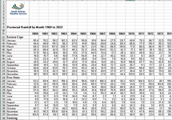
The product provides a general overview of rainfall across the country. It is ideal for clients who are only interested in one rainfall value per province per month. |
|
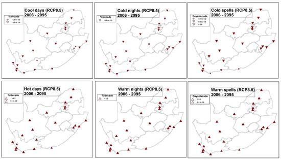
Climate Change Reference Atlas (CCRA) |
Provide a Hyperlink: https://www.weathersa.co.za/home/climatechangeatlas https://www.weathersa.co.za/home/extremeclimateindices
|
|
Additional Information |
|
|
Data Type |
NC, Shapefiles, Jpeg |
|
File Format |
Shapefiles, Jpeg |
|
Frequency |
5 years cycle |
|
Thematic Application Area/ Target Market |
· All Sectors |
|
Coverage |
National, Provincial and municipality |
|
Dissemination Channels |
Product reports are available on the website. Raw data for further value add are available upon request and commercial terms |
|
Product Benefits/Impact to end – user |
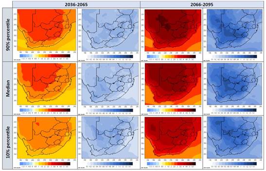
The Climate Change Reference Atlas provides a general impression of climate change scenarios compared to the present climate, at a high resolution of ~4 km. These scenarios are for various periods and emission scenarios and can assist with initial long-term planning for all climate-sensitive sectors. The information can serve as a preparatory phase for more in-depth future scenario research, relevant to a specific sector. |
|
Climate Data (CD) |
|
|
Additional Information |
|
|
Data Type |
Text |
|
File Format |
MS Excel, MSWord, Pdf |
|
File Size |
Request dependant |
|
Frequency |
Upon request |
|
Thematic Application Area/Target Market |
· All Sectors |
|
Coverage |
South Africa |
|
Dissemination Channels |
|
|
Product Benefits/Impact to end – user |
Long-term analysis, understanding of weather and climate of the area, verification of weather conditions in the area. |
|
Specialized Lightning Report (SLR) |
|
|
Additional Information |
|
|
Data Type |
Text or Excel |
|
Data Formant |
Report PDF or MSWord |
|
File Size |
Small /Medium |
|
Frequency |
Upon request |
|
Thematic Application Area/Target Market |
· All sectors |
|
Coverage |
South Africa |
|
Dissemination Channels |
|
|
Product Benefits/Impact to end – user |
To accurately determine the position and strength of a ground strike. Used to validate insurance claims. |
|
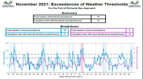
Marine Portals and Custom Operational Services (MPCOS) |
Provide a Hyperlink : https://marine.weathersa.co.za/Products_Services_Ports.html
Monthly Reports:
|
|||
|
Additional Information |
||||
|
Data Type |
Variable |
|||
|
File Size |
Variable (Depends on Request) |
|||
|
Frequency |
As Required |
|||
|
Thematic Application Area/Target Market |
· Marine Applications |
|||
|
Coverage |
South Africa |
|||
|
Dissemination Channels |
· Web Portals and Reports. |
|||
|
Product Benefits/Impact to end – user |
Provide specialised products developed according to clients' needs and thresholds such as predicting the amount of downtime of operations (ports or shipping), ideal conditions for research or operational surveys, forecasting for coastal field work or diving operations, etc. |
|||
|
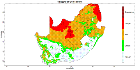
Animal Heat Stress Index (AHSI) |
THI Index for Dairy Cows:
|
|
Additional Information |
|
|
Data Type |
|
|
File Format |
JPEG and CSV |
|
File Size |
3 Mb |
|
Frequency |
1 x per day |
|
Thematic Application Area/Target Market |
· Agricultural Sector |
|
Coverage |
South Africa and Southern Africa |
|
Dissemination Channels |
· Web Portal · Mobile APP · Social Media |
|
Product Benefits/Impact to end – user |
Heat stress indices are used to assess the risk of heat stress in dairy cattle, beef cattle and poultry. The product will quantitatively inform the management of dairy and beef cattle and poultry cooling needs to at least minimize the impacts of heat stress on milk and beef production and broilers. |
|
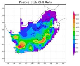
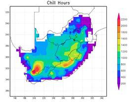
Heat and Chill Units (H&C)
|
Provide a Hyperlink
|
|
Additional Information |
|
|
Data Type |
Maps, txt, xlsx |
|
File Size |
Small/Medium |
|
Frequency |
Hourly, daily |
|
Thematic Application Area/Market |
· Agriculture · Biodiversity · Ecology
|
|
Coverage |
South Africa |
|
Dissemination Channels |
· Web Portal · Mobile APP · Social media |
|
Product Benefits/Impact to end – user |
· Heat units are used to assess the suitability of a region for crop production; t o select suitable hybrids and varieties; estimate the growth-stages of crops, weeds, and life stages of insects; predict best timing of fertilizer or pesticide application; and to plan spacing of planting dates to produce separate harvest dates . · Chill units are used to predict the end of the dormancy period, to determine time for cultivation practices, and to identify potential growing locations. |
|
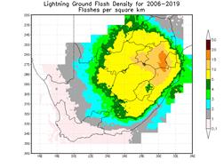
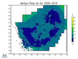
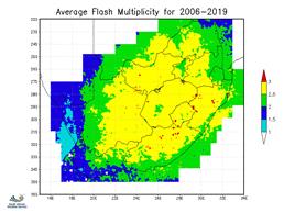
Lightning Climatology (LC) |
|
|
Additional Information |
|
|
Data Type |
Images can be provided in standard formats such as GIF, PNG, JPEG or in documents such as Word and PDF. An option is also available to provide data in text files, Excel, or shapefile format. |
|
File Size |
25 kb – 20+ mb dependent on format. |
|
Frequency |
Annual |
|
Thematic Application Area/Target Market |
· Insurance · Lightning Protection · Energy · Construction · Forestry · Transportation · And other sectors concerned with lightning distributions.
|
|
Coverage |
National and can be tailor-made at the provincial, municipality or point location level.
|
|
Dissemination Channels |
Information is typically provided by email but can be provided by other dissemination channels as requested by clients. |
|
Product Benefits/Impact to end – user |
Lightning climatological information provides important insights into the typical distribution and characteristics of lightning across South Africa which is extremely valuable for lightning protection standards, risk assessments, and planning. |
10
|
Lightning Stroke Detection (LSD) |
http://cyclone-web.saws.co.za/ncastweb/lightning_5mn.html
|
|
Additional Information |
|
|
Data Type |
ASCII |
|
File Format |
|
|
File Size |
Small |
|
Frequency |
1 minute |
|
Thematic Application Area/Target Market |
· DRR · Insurance · Schools · Aviation · Sport and recreation · Mining · Forestry · Transportation · Energy · Construction |
|
Coverage |
South Africa |
|
Dissemination Channels |
· Web portal · Mobile APP · Social media |
|
Product Benefits/Impact to end – user |
The product provides gridded near-real-time lightning maps to monitor lightning activity anywhere in South Africa with the capability for clients to view the current location of lightning storm cells and the intensity thereof. This product can be used for decision making to stop activities when a storm approaches and to resume activities once the threat is over. |
|
Monthly Drought Bulletin |
|
||||
|
Additional Information |
|||||
|
Data Type |
|
||||
|
File Size |
|
||||
|
Frequency |
Monthly |
||||
|
Thematic Application Area/Market |
· Government · Farmers · Researchers · Universities · Financial sectors etc |
||||
|
Coverage |
South Africa |
||||
|
Dissemination Channels |
SAWS website: https://www.weathersa.co.za/Documents/Climate/nr_drought.pdf
|
||||
|
Product Benefits/Impact to end – user
|
The product serves as a valuable tool for decision makers in government, enabling them to effectively monitor drought conditions and allocate resources accordingly. It is also useful across different sectors, i.e., farmers for planning purposes, investors, and insurance companies. Researchers may use the product to pick up case studies for further investigations. |
||||
12
|
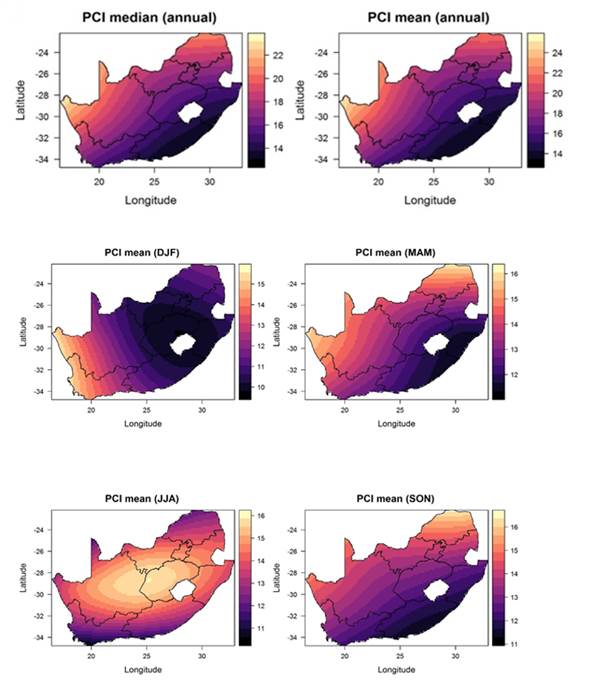
Precipitation Concentration Index (PCI) |
|
|
Additional Information |
|
|
Data Type |
|
|
File Format |
Word, JPEG, PDF |
|
File Size |
|
|
Frequency |
Seasonal, supra-seasonal and annual |
|
Thematic Application Area/Target Market |
· Water · Agriculture |
|
Coverage |
National, provincial, and tailor-made spatial scale |
|
Dissemination Channels |
Product reports are available on request. Other means of dissemination are being explored, including dissemination through SAWS website. |
|
Product Benefits/Impact to end – user |
The PCI can be used as an indicator for hydrological risks such as drought and flood, including to facilitate the flow rate from high to lower, thereby eliminating floods. The PCI can also be used for flood risk assessment, water resources management and agricultural planning. |
13
|
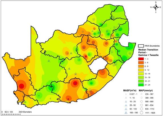
Drought Propagator (DP) |
|
|
Additional Information |
|
|
Data Type |
|
|
File Format |
Word, JPEG, PDF |
|
File Size |
|
|
Frequency |
Annual |
|
Target Market |
· Water Sector · Agriculture |
|
Coverage |
National, provincial, and tailor-made spatial scale |
|
Dissemination Channels |
Product reports are available on request. Other means of dissemination are being explored, including dissemination through SAWS website. |
|
Product Benefits |
Applications of drought propagator include drought monitoring & prediction, drought risk assessment, water resources management & planning as well as for agricultural planning. |